
Today's post takes us to Lo Manthang, the capital of the Kingdom of Lo, also known as Upper Mustang, in the depths of the Himalayas.

The journey begins with the landing of the flight from Kathmandu at the small airport of Jomsom. No need to explain the difficulties in landing at this airport. If the level of Grise Fjord airport was fourth on the WGSP scale (Whiskey Glasses for "Sedative Purposes"... you need to drink before takeoff), Jomsom should be level 6 (serious accidents in 2012 and 2013). Jomsom area, although belonging to the Mustang District, is at so called Lower Mustang, which has nothing to do with the real Kingdom of Mustang. The population is ethnically Takhali and their language is not intelligible with Tibetan, although both share the same language group.

When leaving Jomsom following up the Kali Gandaki river, the road climbs to 4.000m passing by, always following the river, in between two giants, Annapurna (8.091m) and Dhaulagiri (8167). Even trekking near these major summits, the path keeps quite easy and you don't need to be an expert mountaineer to do it. The road, right now, has been improved to allow motor vehicles. But it is quite common to find "traditional transportation": rows of iaks loaded with goods.

Before reaching Kagbeni, the town that marks the entrance to the Upper Mustang, the Kingdom of Lo, you need to cross a magnificent bridge over the Kali Gandaki river. It's a modern version of traditional Tibetan bridges. If wind does not blow, crossing it's just a matter of managing your vertigo. This modern Tibetan bridge can be crossed, apart from walking, riding a horse, with Yak, or even by bike ...
Kagbeni village (1,200 inhabitants) has a main crossroads. Well, crossroads means several roads and, to be honest, there is only one real road: that heading towards Muktinath. The other one, direction Lo Manthang, our destination, is merely a path. If it's not enough remote it wouldn't be interesting!

The route continues up along Kali Gandaki river, but now limited to iak caravans or, of course, those who prefer to walk. The river is a succession of rapids, rocks and eddies.This wild and indomitable river calls me up the 70's explorer Michel Peissel (Peissel and Heinrich Harrer's books made me discover Tibet and the Himalayas in my early youth). He had the idea to navigate upstream the Kali Gandaki river using small hovercrafts! Suffice to say that, from three hovercraft at the starting point, just one was able to finish the expedition, and Michel Peissel and a companion were about to drown. after a crash against some hidden rocks

Next town in the valley is Tsarang. The sorroundings are, now, a typical Tibetan landscape: barren mountains, rocks, soil and dust and, down in the valley, where the river passes by, trees, fields and villages confined at the river banks. In fact, despite being formally Nepal, once past the Annapurna and Dhaulagiri, we are on the northern slope of the Himalayas and therefore, the clouds that make India and Nepal have a very humid climate can not cross the mountains. Thus, both the Mustang and Tibet have extremely arid climates.The traditional white houses of Tsarang are overlooked by the monastery of Gompa Tsarang: It's just like having returned to Tibet 100 years ago.

The
final descent towards Lo Manthang, the capital of the Kingdom, from one of
the hills surrounding the city allows the visitor to admire the river plain where
the walled city emerges with its red and white colors. Behind the city, standing up in the hill, there is a fortress in ruins. From
this castle, during the fourteenth century, Ame Pal founded the Kingdom of Lo
in one of the natural pathways between Tibet and India. This natural passage through the Himalayas turned into the
passageway used by merchants with their iak caravans carrying salt from Tibet and returning with
rice, tea and other products from India.
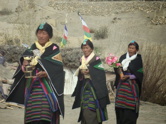
Lo Manthang, capital of the kingdom, has a thousand inhabitants, and so, roads and fields around town bustle with people going back and forth. Lhobas, like Tibetans (in fact, Lhobas are ethnically Tibetans) like to dress in a luxurious; men and women wear colorful costumes and many jewels according to their social status. Inhabitants of the Kingdom of Lo ar called Lhobas or Lhopas as "-pa" is the suffix in Tibetan to mark demonym of a place. Thus, a resident of Lo is a Lhopa, as a resident of Lhasa is a Lhasapa, and the Zanskar one is a Zanskarpa.

Even now, as in the last 700 years, the doors of the wall still get closed after nightfall, and open again at sunrise. Since the Kingdom was opened to tourism in the 90's, things have changed a lot (well, quite ..... well, leave it in a bit ...) regarding tourism infrastructure: there is now a hotel and a lodge for the 2,000 visitors a year who get permission (and pay the $50 daily rate to the Nepalese government) to visit the kingdom called by its inhabitants simply "Lo". The also used name Mustang is a distortion from Lo Manthang. Manthang, or Tan Mun in Tibetan, means "fertile plain", following the same criteria of "geography advertisment" also used, for example, when Viking Erik the Red named "Green Land" (Grønland) a mere block of ice and snow!
In the coming post I will show you this city of narrow streets, with a royal palace in which chickens can roam wherever they want (even when someone is received by the king) and we will know what CIA was doing in the Kingdom of Lo. Meanwhile, if you can wait no longer and have already your luggage ready to leave, here's a useful link for your accommodation in Lo Manthang and the rest of Mustang.

No comments:
Post a Comment