Showing posts with label Canada. Show all posts

Sunday, 31 March 2019

A -60ºC emergency rescue

If someone has a medical emergency, the logical reaction is to call an ambulance. In a small village, in the worst case, the ambulance must come from a larger town. Then, you would have to wait between 5 and 15 minutes for the ambulance to come. But what do you do if you really need an ambulance and you're in the South Pole in the middle of the austral winter?

In June 2016 a medical rescue expedition was made to evacuate two ill workers from the Amundsen-Scott station, located exactly at the geographical South Pole. I would like to point out that these days, in the northern hemisphere, you were enjoying the longest days of the year and, therefore, in the South Pole, they were in the middle of the austral winter. This means 24 hours of absolute darkness and, the feeling that if you are at -50ºC, you're enjoying a warm wave.

But before explaining how the two patients had to be evacuated, let me explain how life is at the Amundsen-Scott station.

The first building of the Amundsen-Scott base was built, exactly in the geographic South Pole in 1956. The base obviously bears the name of the first two expeditions that reached the South Pole: the first one, the Norwegian expedition, leaded by Roald Amundsen, followed some days later by Captain Robert Falcon Scott's British expedition which, apart from losing the race, ended up in misfortune, dying all the components of the expedition of famine and cold on the return journey.
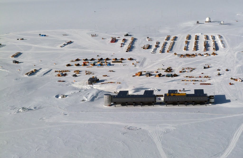


After successive extensions, demolitions and remodelings, the base is currently made up of a main building (the gray one, in front at the photo), and a whole series of small auxiliary buildings that perform as laboratories, workshops... If you look at the image, in the foreground just in front of the main building, you will see a small half-circle shaped by what might look like poles or stakes. In fact, they are the flags that enclose the exact point that, at that time, occupies the Geographic South Pole. And I say "at that moment" because the Base is located on a giant glacier that moves about 10 cm. each year. So, from time to time, they need to dismantle the whole thing and re-place it on the right place.


The current building, the gray one on the photo, is quite interesting. Do you see that it is suspended over a kind of pillars? Here you can see it better:


These pillars are hydraulic and can be raised up to twenty centimeters. As ice moves, there could be different settlements throughout the building. When this happens, the height of a pillar is extended or decreased and problem gets solved.

The other curious point is this sloppy lower part of the building (just above pillars' head). This is intended to use wind when blowing. The air is forced to divert below the building and, when following this path, the wind accelerates and helps the recent snow to get cleaned from below the buildings. You might think that the South Pole has a very dry climate (it is really far from the sea), and receiving only around 20cm per year, snow shoudn't be a problem. But this snow never disappears; It always accumulates. If fresh snow under the buildings doesn't get removed, in a few years they would be buried!

The base has all kinds of comforts for almost 200 inhabitants in the summer, and 50 in the winter: gym, sports field, library, games room, cinema, greenhouse, a small hospital. Seems not so bad ...

Standard bedroom at the Base

At the shop you can buy clothes, food, sweets, alcohol and, also, rent a DVD.

Sports court is also used as a conference room.

Dining room with Christmas decoration... during austral summer, of course!

Here you have a video with a promenade inside Amundsen-Scott Base:


Life conditions, however, are very hard. And especially for the fifty or so people that stay there during winter season. The average temperature during april to septemeber is... -60ºC. And this is only the average, because it's quite easy to go below -70ºC (lowest ever recorded temperature was -82,8ºC). Would you like to know what do you need to wear for these temperatures? Watch it in the next video:


But coldness isn't the worst thing (you should already know that cold weather is never a problem in this blog). The worst is that, during anctartic winter, Amundsen-Scott Base "enjoys" 6 months of absolute night and darkness. Yes, This is the only point on the planet that, every year, only has one dawn and one dusk. It means that every year, around mid-March, the sun goes down and doesn't gets back until mid-September. On September 21st, the first day that the sun appears, it will stay permanently in ths sky until next March.

Fantastic! Temperatures around -60ºC and total darkness. And when a say total darkness means.... total! There's no luminic contamination in a circle of 2.000km so sky is dark black with thousands of stars. For the 50 braves that "hibernate" at the Base, the psychologic challenge is really harsh. Moreover, they are almost totally isolated, except by phone and internet. Basically all hibernants are workers that maintain the Base, and some scientists that need to do their research during austral winter.


And what about the rescue mission? In May 2016, two hibernants felt ill and couldn't be treated at the basic Base hospital. The only way to save their lifes was evacuation. The first problem was how to find a plane capable of landing in such conditions. Usually, the route is served by New Zealand planes, but they are only prepared for summer flights. If they wanted to find planes (and pilots) with the capability for that flight, they should search in.... Canada!

Kenn Borek Air is, probably, one of the more "extreme" airlines of the world. Their main specialty is flying the Canadian Arctic routes, so they owned two Twin Otter planes prepared for temperatures below -70ºC. Both bimotors took off from Calgary, Canadà and, one week and 16.500Km later, one of the two planes landed at Amundsen Scott Base, picking up both patients. Whatch the conditions under which the rescue took place:


Although the small inconvenients that staying a winter in Scott-Amundsen Base has, belive me; if I got the proposal of going there, I would pack my suitcases immediately!

Monday, 28 November 2016

Whiskey War (and also Schnapps!)

International law states that National Territorial waters extend up to 12 nautical miles (about 22 km.) from the coast of each country. In the case of narrow straits, such as the Strait of Gibraltar, cosidering both countries are so close to eachother, the limit of territorial waters is set at the midpoint between the two coasts. But that would happen with an island right in the middle point?


In Nares Strait, north of Greenland, the line between territorial waters of Canada and Denmark (for the moment, Greenland is still part of the Danish territory) is set about 10 miles from both sides. And right at that midpoint lies Hans Island, a piece of rock just a little bigger than 1 Km. from end to end. As you can see in the picture, following this blog's tradition, Hans Island is a very busy place. The nearest towns are Canadian Forces Base "Alert"  (the most northerly inhabited place on the planet) and the villages of Qaanaaq and Siorapaluk in Greenland, all both located more than 200 km far.


During the 30's, the League of Nations (predecessor of the UN) established that Hans Island belonged to the Danes. But Canadians alleged that, with the disappearance of this institution, the decision is invalidated and, for the moment, United Nations doesn't want to get their feet wet.

For more than 70 years, the two governments agreed a list of 127 geographic points that delimited the maritime boundary between both countries in the Nares Strait. But between points 122 and 123, they decided not to draw any lines there and, therefore, not define the border: it was Hans Island.


But don't think that this remains quiet. Tension between the two countries is very strong and we could even talk of one of the hottest geopolitical spots of the world: a sample of uncontrolled violence, is repeated every year of confrontation between Canadian Armed Forces and Danish "Forsvaret" (Army).

Every August, Canadian Army carries out some military exercises in the area of ​​Ellesmere Island. When Canadians pass near the Hans Island, they land there a few soldiers and remove the Danish flag, hoist the Canadian one, and next to the mast they leave a bottle of Canadian whiskey with a message: "Welcome to Canada". The Danish army remains not far behind the aggresive Canadians in the disproportionate use of force. And so, every spring, they send a detachment to Hans Island which is responsible of picking up the flag of Canada, place the Danish one and, after drinking the Canadian whiskey, they let a bottle of Schnapps with a letter that says: "you are in the territory of Denmark."

The maximum tension, however, occurs when vessels of Danish and Canadian Armies found eachother in the viccinity of Hans Island: in order to frighten the enemy, each boat .... hoists a flag of their own country!


No doubt that, the so called "Whiskey War" is limited to a merely exchange of liquor bottles because the object disputed, Hans Island, is only rock; bare, icy and inhospitable. Despite this, during the 80's, Canadian Company Dome Petroleum did some research on the island. There were, however, neither oil nor gaz. It is clear, therefore, that tiny Hans Island does not have any value at all; Well, yes, a bottle of whiskey and schnapps per year.

But disputes over Hans Island are not limited to Canada and Denmark. Some years ago, a  mysterious internet-based "Hans Island Liberation Front" appeared. The independence movement is led, with an iron fist, by two mysterious men ... Hans and Hans.


The last act of protest by Hans Island Liberation Front has been to propose that, seeing the strong expansionism of Russia in the Arctic, Santa Claus should move to live to Hans Island. "We try to avoid" said one of the two Hans (it's unclear if it was Hans or... Hans), "that poor Santa Claus gets forced by the Russians to present, as Christmas gifts, only vodka, LADA cars spare parts and back issues of Pravda newspaper!"


Sunday, 18 September 2016

Further north there's nothing else


If anyone had the vain hope of finding this blog full of tropical paradise islands, let me say, I'm sorry, you won't find many beaches with coconut palms (never say never). I do not want to cheat you; at Grise Fjord it cools down a little bit, especially at night.

In 1953, the Canadian government carried out a plan to populate the Canadian Arctic in an attempt  to prevent the threat posed by the Soviet claims at the Arctic. So they decided to establish several villages and "friendly invited" (maybe "clearly forced" would be more accurate) tens of Inuits to settle in the far north. Two towns were created: Resolute on Cornwallis Island, and Grise Fjord on Ellesmere Island.


Further north, there is nothing else. Well, yes, there is a weather station called Eureka and even further north you can find CFS Alert (Canadian Forces Station Alert) a Canadian military base that deserves a post by itself.
 
So, we are just 1500km from the North Pole. The name of Grise Fjord (Fjord pigs) was given by Norwegian explorer Otto Sverdrup who said that walrus scream,very abundant in the area, resembled that of pigs. Inuit name for Grise Fiord is Aujuittuq and is written (in Inuit): ᐊᐅᔪᐃᑦᑐᖅ. 

The few families that the Canadian government fooled 50 years ago to come live in this place, found on arrival that promised houses were not even built. In addition, the compromise of returning home after one year was fake; the presence of inhabitants at Grise Fjord was becoming more and more important than ever (or at least, this is what was believed at the offices in Ottawa), so Canadian Government decided that the settlement should become permanent. Luckily the new settlers of Ellesmere Island (an island nearly as large as Britain having the people of Grise Fjord as the only inhabitants) were able to learn the habits of migratory whales. The hunting of whales ended up becoming his salvation preventing them to die of starvation.


40 years later, in 1993, a parliamentary commission concluded that the so-called High Arctic Relocation was actually a forced displacement of Canadians; the government formally apologized and compensated those first families and their descendants with 10 million Canadian dollars.

Currently, Grise Fjord is home to about 130 people. A few years ago, the population reached almost 200 inhabitants, but the isolation and lack of opportunities has made the village population drop considerably. But this trend is beginning to change: the eco-tourism industry has come to Grise Fjord, and with it, employment opportunities for Grise Fjord youth.


Curiously, apart from having the record as the most northerly town throughout America, Grise Fjord also holds another record: the town has the less crime ratio throughout Canada. Considering that Canada is itself a fairly safe country, we could argue Grise Fjord is one of the safest destinations in the world!


This destination is easily accessible even if it takes some time: First you need to fly to Iqaluit (via Montreal). From Europe, and considering the transfer at Montreal, assume just 30 hours. Iqaluit Airport is the largest in Nunavut, the Canadian region where Grise Fjord is. And this is the main airport from where Air Nunavut flights take off. The plane will arrive at Resolute Bay after 5 hours of flight over the Canadian tundra and, if you are lucky, you will be able to link directly (even if you should spend a night in Resolute Bay, it's worth!) with next flight. Kenn Borek Air plane will take , in just 1:30 hours at the small airport of Grise Fjord.


What are 40 hours of flights and airports if the goal is to reach this paradise of ice and tundra! Oh! Yes! Those who suffer from fear of fying, I recommend you to take a Diazepam (or failing that, four whiskeys on its own) before leaving Iqaluit. Both the flight to Resolute Bay as the one to Grise Fjord are flown mostly with twin-engine cargo planes so it moves a lot!. Oh, and the approach to the small dirt road from Grise Fjord is, according to experts, one of the most complex in North America. In this video you can see what it means landing at Grise Fjord during autumn (and there is sunlight!). If someone is able to distinguish the runway 10 seconds before the plane touches the ground, you win the prize!


Once in Grise Fjord, you'll find a hotel, a shop where, apart from all the essentials to survive the Arctic, you can buy Inuit handicrafts, and a medical center. If you prefer to go directly to the adventure, you can stay in a camp organized here either to see fauna (whales, narwhals, seals and walruses and polar bears) as going hunting.


If you are traveling in the summer, keep calm: during many hours of the day (May to early August lasts 24 hours) you can reach 5ºC (41ºF) positive! If you decide to travel there in winter (no sunlight from November to February) please wear at least a cardigan, because temperatures reach often -50ºC (-60ºF)!